NOTE: The data shown here is based on the 2021 glacier update at Mount Rainier, and should be considered the most up-to-date data on glaciers at the park (2023-04-06).
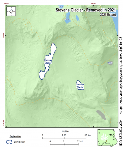
Stevens Glacier
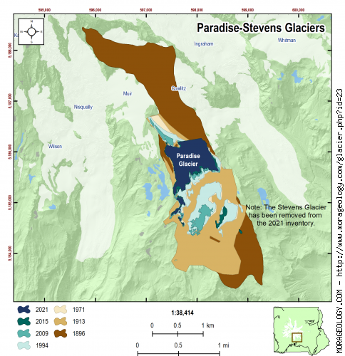
Hazard Stevens, son of Isaac I. Stevens, was born at Newport, Rhode Island, June 9,1842. He accompanied his father in the treaty making expeditions of 1854 and 1855 and served on the General's staff and was wounded in the Battle of Chantilly when his father was killed. On August 17,1870, with P. B. Van Trump he made the first successful ascent of Mount Rainier. The Stevens Glacier which is below the Paradise Glacier on the south side of Mount Rainier has nearly disappeared.
NOTE: As of surveys in 2021, the Stevens is no longer an active glacier at Mount Rainier. Information is included here for reference only. (Reese, 2009)
Switch Glacier:
|
STATISTICS AS OF 2021 (Beason et al., 2023):
Aerial Extent:
0.000 ± 0.000 square miles
(-0.001 ± -0.001 km2)
(Rank: -999 of 29)
Debris Cover - Based on data from 2015 (Beason, 2017):
--No appreciable debris cover in 2015--
Estimated Glacier Volume: (See notes below)
0.0000 ± 0.0000 cubic miles
(0.0000 ± 0.0000 km3)
Highest Elevation (Head):
6,812 feet
(2,076 m)
Lowest Elevation (Terminus):
6,629 feet
(2,021 m)
Elevation Range:
183 feet
(56 m)
Length:
0.05 miles
(0.09 km)
Average Slope:
19.98°
Average Flow Direction (direction the glacier flows towards):
East southeast (123°)
Glacier Type:
C - Cirque Glacier, or Glacier Head Starts Below Summit |
|
CHANGE IN EXTENT, 1896-2021 (Beason et al., 2023):
| Units |
1896 |
1913 |
1971 |
1994 |
2009 |
2015 |
2021 |
| Area, mi2 |
-- |
-- |
-- |
-- |
0.039 |
0.013 |
-- |
| Area, km2 |
-- |
-- |
-- |
-- |
0.101 |
0.033 |
-- |
Area Change Between Periods
|
1913 |
1971 |
1994 |
2009 |
2015 |
2021 |
| 1896 | -- | -- | -- | -- | -- | -- |
|---|
| 1913 | -- | -- | -- | -- | -- | -- |
|---|
| 1971 | | -- | -- | -- | -- | -- |
|---|
| 1994 | | | -- | -- | -- | -- |
|---|
| 2009 | | | | -- | -0.026 mi2
(-0.068 km2) | -- |
|---|
| 2015 | | | | | -- | -- |
|---|
Percent Change Between Periods
|
1913 |
1971 |
1994 |
2009 |
2015 |
2021 |
| 1896 | -- | -- | -- | -- | -- | -- |
|---|
| 1913 | -- | -- | -- | -- | -- | -- |
|---|
| 1971 | | -- | -- | -- | -- | -- |
|---|
| 1994 | | | -- | -- | -- | -- |
|---|
| 2009 | | | | -- | -67.23% | -- |
|---|
| 2015 | | | | | -- | -- |
|---|
|
|
ESTIMATED CHANGE IN VOLUME, 1896-2021 (Beason et al., 2023):
PLEASE see important notes about this, below...
Glacier-specific Scaling Parameter, c:
0.022265
| Units |
1896 |
1913 |
1971 |
1994 |
2009 |
2015 |
2021 |
| Volume, mi3 |
-- |
-- |
-- |
-- |
0.0002 |
0.0001 |
-- |
| Volume, km3 |
-- |
-- |
-- |
-- |
0.0010 |
0.0002 |
-- |
Volume Change Between Periods
|
1913 |
1971 |
1994 |
2009 |
2015 |
2021 |
| 1896 | -- | -- | -- | -- | -- | -- |
|---|
| 1913 | -- | -- | -- | -- | -- | -- |
|---|
| 1971 | | -- | -- | -- | -- | -- |
|---|
| 1994 | | | -- | -- | -- | -- |
|---|
| 2009 | | | | -- | 0.000 mi3
(-0.001 km3) | -- |
|---|
| 2015 | | | | | -- | -- |
|---|
Percent Change Between Periods
|
1913 |
1971 |
1994 |
2009 |
2015 |
2021 |
| 1896 | -- | -- | -- | -- | -- | -- |
|---|
| 1913 | -- | -- | -- | -- | -- | -- |
|---|
| 1971 | | -- | -- | -- | -- | -- |
|---|
| 1994 | | | -- | -- | -- | -- |
|---|
| 2009 | | | | -- | -78.23% | -- |
|---|
| 2015 | | | | | -- | -- |
|---|
Important comments about the calculation of volume shown here
The calculation of glacial volume shown on this page is based on an analysis of two methods used at Mount Rainier in the past (Driedger and Kennard [1986]; and Nylen [2001]) as well as the most recent literature review for glacier area-volume scaling (Please review Beason et al. [2023] for an in-depth discussion about this issue). It should be noted that simply converting area to volume with an equation is extremely difficult and the values presented here have extremely large error margins (likely ± 35% or more). With that in mind, the values presented here should give you an estimate of the glacial volume and change in volume over time. Please use these data very carefully with those caveats.
The calcuation of the volume is as follows:
\[V_i = {(c_iA_i^{1.375}) + (c_nA_i^{1.36}) \over 2}\]
Where:
\(V_i\) = Average volume for the glacier in question (km3);
\(c_i\) = The glacier-specific scaling parameter (back-calculated from glacier area and volume in 1971 in Driedger and Kennard (1986); Method described in Beason et al. (2023). The value for the Stevens Glacier is 0.022265 (this is also listed above the volume graph);
\(c_n\) = The back-calculated scaling parameter from Nylen (2001) of 0.0255; and
\(A_i\) = The measured volume of the glacier in question (km2).
This is essentially an average of the back-calculated Dreidger and Kennard (1986) and Nylen (2001) methods (D&K is in the first parenthesis; Nylen in the second). For example, for the Stevens Glacier in 2021, you can find the following individual volumes:
Back-calculated Dreidger and Kennard (1986) Method: nan mi3 (nan km3).
Back-calculated Nylen (2001) Method: nan mi3 (nan km3).
Average of the two (above equation and values listed for 2021 here): nan mi3 (nan km3).
Official volume estimate listed above, with error: 0.0000 ± 0.0000 mi3 (0.0000 ± 0.0000 km3).
As you can see, the D&K method tends to produce higher values and Nylen produces lower values; the average of these two methods probably estimates the glacial volume. Until further research is done in this area and we can develop a better method or equation to determine volumes, this is the method we are using to determine glacial volumes. For more information about this method, please read the methods section of Beason et al. (2023).
|
NOTES:
Extent of this glacier from 1896-1994 was included with the combined Paradise/Stevents Glacier system. See Paradise Glacier for extent change over time. As of 2021, the Stevens is no longer an active glacier at Mount Rainier National Park.
RAW DATA: