Switch Glacier:
NOTE: This page has been updated to show 2021 extents and changes
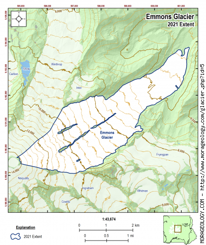
Emmons Glacier
Emmons Glacier, the largest on Mount Rainier, was named for Samuel Emmons who, with A.D. Wilson, made the second successful ascent of Mount Rainier. (Meany, Mount Rainier p. 308). A pamphlet published by Fred G. Plummer of Tacoma lists this glacier as Blaine for Senator James G. Blaine of Maine and it was called the Blaine Glacier by the Seattle Post Intelligencer Expedition of December, 1894. Samuel Franklin Emmons was born in Boston on May 29, 1841. He was an eminent geologist who was part of the U.S. Geological Survey exploration of the 40th parallel. He died March 28, 1911. (Reese, 2009)
|
STATISTICS AS OF 2021 (Beason et al., 2022):
Aerial Extent:
4.188 ± 0.220 square miles
(10.847 ± 0.570 km2)
(Rank: 1 of 29)
Debris Cover (Based on Beason, 2017 - not updated in 2021):
1.149 ± 0.066 square miles
(2.975 ± 0.171 km2)
(Rank: 2 of 29)
Estimated Glacial Volume: (See notes below)
0.1062 cubic miles
(0.4427 km3)
Highest Elevation (Head):
14,148 feet
(4,312 m)
Lowest Elevation (Terminus):
4,883 feet
(1,488 m)
Elevation Range:
9,266 feet
(2,824 m)
Length:
4.55 miles
(7.32 km)
Average Slope:
24°
Average Flow Direction (Flows towards):
Northeast (55°)
|
|
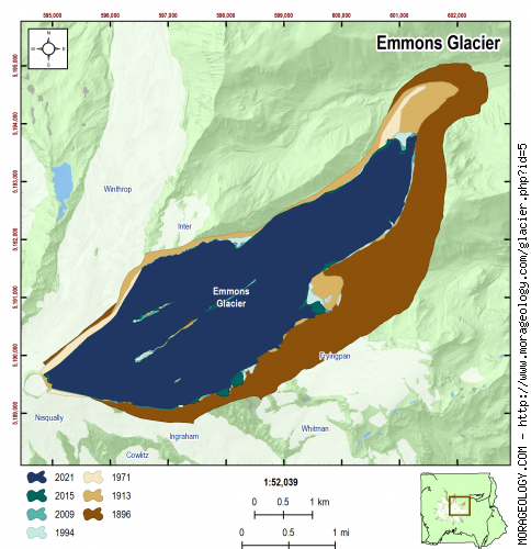
CHANGE IN EXTENT, 1896-2015 (Beason, 2017):
| Units |
1896 |
1913 |
1971 |
1994 |
2009 |
2015 |
2021 |
| Area, mi2 |
6.741 |
4.873 |
4.308 |
4.333 |
4.239 |
4.258 |
4.188 |
| Area, km2 |
17.458 |
12.622 |
11.158 |
11.223 |
10.979 |
11.027 |
10.847 |
Area change between periods
|
1913 |
1971 |
1994 |
2009 |
2015 |
2021 |
| 1896 |
-1.867 mi2
(-4.836 km2) |
-2.432 mi2
(-6.299 km2) |
-2.407 mi2
(-6.235 km2) |
-2.501 mi2
(-6.479 km2) |
-2.483 mi2
(-6.431 km2) |
-2.553 mi2
(-6.611 km2) |
| 1913 |
-- |
-0.565 mi2
(-1.464 km2) |
-0.540 mi2
(-1.400 km2) |
-0.634 mi2
(-1.643 km2) |
-0.616 mi2
(-1.595 km2) |
-0.685 mi2
(-1.775 km2) |
| 1971 |
|
-- |
0.025 mi2
(0.064 km2) |
-0.069 mi2
(-0.179 km2) |
-0.051 mi2
(-0.131 km2) |
-0.120 mi2
(-0.312 km2) |
| 1994 |
|
-- |
-0.094 mi2
(-0.243 km2) |
-0.075 mi2
(-0.196 km2) |
-0.145 mi2
(-0.376 km2) |
| 2009 |
|
-- |
0.019 mi2
(0.048 km2) |
-0.051 mi2
(-0.132 km2) |
| 2015 |
|
-- |
-0.070 mi2
(-0.180 km2) |
Percent change between periods
|
1913 |
1971 |
1994 |
2009 |
2015 |
2021 |
| 1896 |
-27.70 % |
-36.08 % |
-35.72 % |
-37.11 % |
-36.84 % |
-37.87 % |
| 1913 |
-- |
-11.60 % |
-11.09 % |
-13.02 % |
-12.64 % |
-14.07 % |
| 1971 |
|
-- |
0.57 % |
-1.61 % |
-1.18 % |
-2.79 % |
| 1994 |
|
-- |
-2.17 % |
-1.74 % |
-3.35 % |
| 2009 |
|
-- |
0.44 % |
-1.20 % |
| 2015 |
|
-- |
-1.63 % |
|
ESTIMATED CHANGE IN VOLUME, 1896-2021 (Beason et al., 2022; George and Beason, 2017):
PLEASE see important notes about this, below...
| Units |
1896 |
1913 |
1971 |
1981* |
1994 |
2009 |
2015 |
2021 |
| Volume, mi3 |
0.1713 |
0.1238 |
0.1095 |
0.1617 |
0.1101 |
0.1077 |
0.1082 |
0.1062 |
| Volume, km3 |
0.7138 |
0.5161 |
0.4563 |
0.6739 |
0.4589 |
0.4489 |
0.4509 |
0.4427 |
* = 1981 was the only year that glacial volumes have been measured. See note below.
Basal Shear Stress (τ): 3,285.02 lbs/ft2
Volume change between periods
|
1913 |
1971 |
1981 |
1994 |
2009 |
2015 |
2021 |
| 1896 |
-0.0474 mi3
(-0.1977 km3) |
-0.0618 mi3
(-0.2576 km3) |
-0.0096 mi3
(-0.0399 km3) |
-0.0612 mi3
(-0.2550 km3) |
-0.0636 mi3
(-0.2649 km3) |
-0.0631 mi3
(-0.2629 km3) |
-0.0650 mi3
(-0.2711 km3) |
| 1913 |
-- |
-0.0144 mi3
(-0.0598 km3) |
0.0379 mi3
(0.1578 km3) |
-0.0137 mi3
(-0.0572 km3) |
-0.0161 mi3
(-0.0672 km3) |
-0.0156 mi3
(-0.0652 km3) |
-0.0176 mi3
(-0.0734 km3) |
| 1971 |
|
-- |
0.0522 mi3
(0.2177 km3) |
0.0006 mi3
(0.0026 km3) |
-0.0018 mi3
(-0.0073 km3) |
-0.0013 mi3
(-0.0054 km3) |
-0.0032 mi3
(-0.0135 km3) |
| 1981 |
|
-- |
-0.0516 mi3
(-0.2151 km3) |
-0.0540 mi3
(-0.2250 km3) |
-0.0535 mi3
(-0.2231 km3) |
-0.0555 mi3
(-0.2312 km3) |
| 1994 |
|
-- |
-0.0024 mi3
(-0.0100 km3) |
-0.0019 mi3
(-0.0080 km3) |
-0.0039 mi3
(-0.0161 km3) |
| 2009 |
|
-- |
0.0005 mi3
(0.0020 km3) |
-0.0015 mi3
(-0.0062 km3) |
| 2015 |
|
-- |
-0.0020 mi3
(-0.0081 km3) |
Percent change between periods
|
1913 |
1971 |
1981 |
1994 |
2009 |
2015 |
2021 |
| 1896 |
-27.70 % |
-36.08 % |
-5.59 % |
-35.72 % |
-37.11 % |
-36.84 % |
-37.98 % |
| 1913 |
-- |
-11.60 % |
30.58 % |
-11.09 % |
-13.02 % |
-12.64 % |
-14.22 % |
| 1971 |
|
-- |
47.71 % |
0.57 % |
-1.61 % |
-1.18 % |
-2.96 % |
| 1981 |
|
-- |
-31.91 % |
-33.39 % |
-33.10 % |
-34.31 % |
| 1994 |
|
-- |
-2.17 % |
-1.74 % |
-3.52 % |
| 2009 |
|
-- |
0.44 % |
-1.38 % |
| 2015 |
|
-- |
-1.81 % |
With the exception of data in 1981, all values here are calculated estimates based on work by Driedger and Kennard (1986), which calculates glacier volumes with the following equations:
If Glacier Length (L) > 8,500 ft:
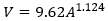
If Glacier Length (L) < 8,500 ft:
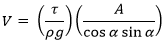
Basal shear stress (τ) is calculated as:
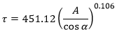
Where V is the calculated volume of the glacier (ft3), A is the calculated area of the glacier (ft2), ρ is the density of ice (1.779 slug/ft3), g is the acceleration of gravity (32.178 ft/s2), and α is the average slope of the glacier.
If you need a really good research project, recalculating the glacier volumes at Mount Rainier is the way to go!
|
NOTES:
Data References:
Beason et al., 2022,
Beason, 2017,
George and Beason, 2017,
Reese, 2009, and
Driedger and Kennard, 1986