ESTIMATED CHANGE IN VOLUME, 1896-2021 (Beason et al., 2022; George and Beason, 2017):
PLEASE see important notes about this, below...
| Units |
1896 |
1913 |
1971 |
1981* |
1994 |
2009 |
2015 |
2021 |
| Volume, mi3 |
-- |
-- |
-- |
0.0129 |
-- |
-- |
0.0087 |
0.0080 |
| Volume, km3 |
-- |
-- |
-- |
0.0538 |
-- |
-- |
0.0361 |
0.0334 |
* = 1981 was the only year that glacial volumes have been measured. See note below.
Basal Shear Stress (τ): 2,671.62 lbs/ft2
Volume change between periods
|
1913 |
1971 |
1981 |
1994 |
2009 |
2015 |
2021 |
| 1896 |
0.0000 mi3
(0.0000 km3) |
0.0000 mi3
(0.0000 km3) |
0.0129 mi3
(0.0538 km3) |
0.0000 mi3
(0.0000 km3) |
0.0000 mi3
(0.0000 km3) |
0.0087 mi3
(0.0361 km3) |
0.0080 mi3
(0.0334 km3) |
| 1913 |
-- |
0.0000 mi3
(0.0000 km3) |
0.0129 mi3
(0.0538 km3) |
0.0000 mi3
(0.0000 km3) |
0.0000 mi3
(0.0000 km3) |
0.0087 mi3
(0.0361 km3) |
0.0080 mi3
(0.0334 km3) |
| 1971 |
|
-- |
0.0129 mi3
(0.0538 km3) |
0.0000 mi3
(0.0000 km3) |
0.0000 mi3
(0.0000 km3) |
0.0087 mi3
(0.0361 km3) |
0.0080 mi3
(0.0334 km3) |
| 1981 |
|
-- |
-0.0129 mi3
(-0.0538 km3) |
-0.0129 mi3
(-0.0538 km3) |
-0.0043 mi3
(-0.0177 km3) |
-0.0049 mi3
(-0.0204 km3) |
| 1994 |
|
-- |
0.0000 mi3
(0.0000 km3) |
0.0087 mi3
(0.0361 km3) |
0.0080 mi3
(0.0334 km3) |
| 2009 |
|
-- |
0.0087 mi3
(0.0361 km3) |
0.0080 mi3
(0.0334 km3) |
| 2015 |
|
-- |
-0.0006 mi3
(-0.0026 km3) |
Percent change between periods
|
1913 |
1971 |
1981 |
1994 |
2009 |
2015 |
2021 |
| 1896 |
0.00 % |
0.00 % |
-5,380,292.00 % |
0.00 % |
0.00 % |
-3,605,672.01 % |
-3,343,682.35 % |
| 1913 |
-- |
0.00 % |
-5,380,292.00 % |
0.00 % |
0.00 % |
-3,605,672.01 % |
-3,343,682.35 % |
| 1971 |
|
-- |
-5,380,292.00 % |
0.00 % |
0.00 % |
-3,605,672.01 % |
-3,343,682.35 % |
| 1981 |
|
-- |
-100.00 % |
-100.00 % |
-32.98 % |
-37.85 % |
| 1994 |
|
-- |
0.00 % |
-3,605,672.01 % |
-3,343,682.35 % |
| 2009 |
|
-- |
-3,605,672.01 % |
-3,343,682.35 % |
| 2015 |
|
-- |
-7.27 % |
With the exception of data in 1981, all values here are calculated estimates based on work by Driedger and Kennard (1986), which calculates glacier volumes with the following equations:
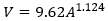
If Glacier Length (L) > 8,500 ft:
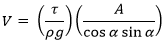
If Glacier Length (L) < 8,500 ft:
Basal shear stress (τ) is calculated as:
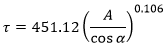
Where V is the calculated volume of the glacier (ft3), A is the calculated area of the glacier (ft2), ρ is the density of ice (1.779 slug/ft3), g is the acceleration of gravity (32.178 ft/s2), and α is the average slope of the glacier.
If you need a really good research project, recalculating the glacier volumes at Mount Rainier is the way to go!
|